
HACKATHON FACH 2020

WINNING PROJECTS OF “HACKATHON FACH 2020” MEASURED CLIMATE EFFECTS IN WETLAND AND GLACIER OF THE CENTRAL ZONE OF THE COUNTRY
- The participating teams developed solutions to measure, monitor and predict the effects of climate change on glaciers, wetlands and forest fires in peri-urban areas, using data and high-resolution satellite images provided by the SAF and the Open Data Cube of the Data Observatory. The contest had the enthusiastic participation of 47 teams made up of citizens, undergraduate and graduate students, academics and researchers.
Three were the winning projects of the FACH 2020 Virtual Hackathon, who demonstrated the applicability of data and satellite images for the development of data science solutions in historical analysis, real-time monitoring and predictive systems on the effect of climate change in the Wetland El Yali of the O’Higgins Region and the Olivares River Basin Glacier in the Metropolitan Region.
The FACH 2020 Virtual Hackathon was organized by the Chilean Air Force through the Aerofotogrammetric Service (SAF), the Data Observatory, and the Faculty of Engineering and Sciences of the Adolfo Ibáñez University (UAI), in partnership with the Ministry of Science, Technology, Knowledge and Innovation, the Ministry of Economy, Development and Tourism, Amazon Web Services (AWS), CSIRO Chile, local office of the Australian research agency, and Fundación País Digital. It had the participation of 47 teams that developed solutions for climatic problems such as forest fires in peri-urban areas, retreat of glaciers and degradation of wetlands, including citizens, undergraduate and graduate students, academics and researchers.
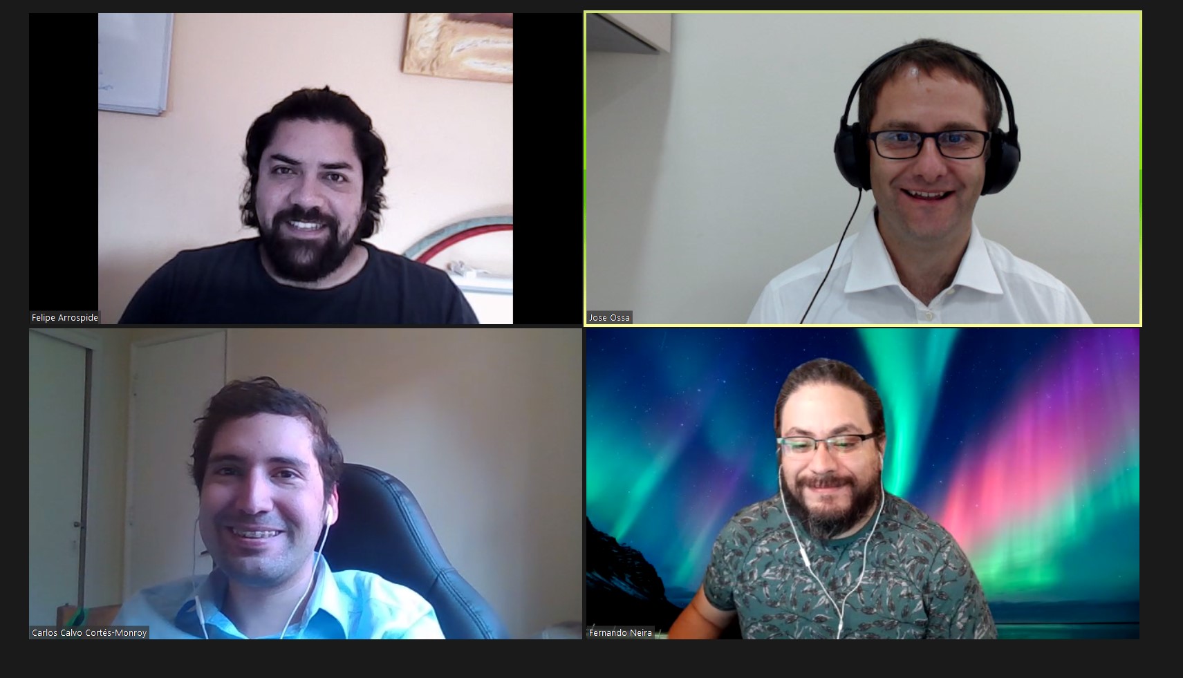
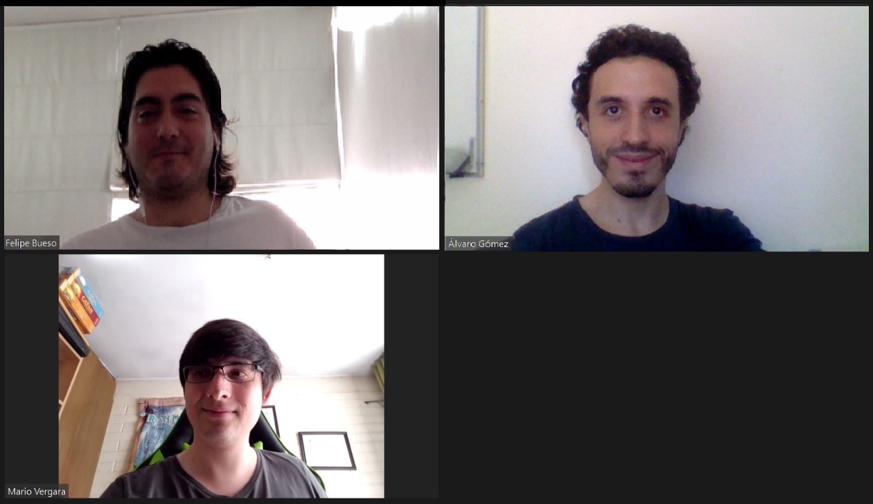
The first 3 places obtained prizes for US $ 5,000, US $ 2,500 and US $ 1,000 AWS credits respectively and their proposals were presented under the names of Chilean volcanoes: Tatajachura, Chaxas and Colachi. The first place was obtained by the Tatajachura team made up of Felipe Bueso, Mario Vergara and Álvaro Gómez, representatives and co-founders of B&G Advanced Analytics; second place went to the Chaxas team, made up of José Ossa, Carlos Calvo, Felipe Arróspide and Fernando Neira, from the Natural Resources Information Center (Ciren); and third place for Colachi, led by Álvaro Salazar, from the University of La Serena.
The teams worked with data provided by the SAF and the Open Data Cube developed by the Data Observatory in collaboration with CSIRO Chile. The selection criteria for the finalists were: solution, use of data, design and presentation. Tatajachura developed indicators for preventive work in the El Yali Wetland; Chaxas, measured incident factors in the retreat of glaciers in the Cajón del Río Olivares; and Colachi, carried out a study of anomalies that help to understand the processes of changes in the El Yali Wetland.
Tatajachura developed a predictive model and a real-time monitoring model with more than 20 indicators of the El Yali Wetland, using satellite data since 2013, highlighting the benefits of the wetland as a water resource accumulator, flora and fauna support, biological pest control and diseases, reduction of the effects of climate change and container of nutrients and pollutants. Chaxas established the relationship between the rainfall record in the Maipo Basin, the increase in temperatures and the effects of drought on the retreat of glaciers, using Landsat 8 satellite data between 2013 and 2020. Finally, Colachi decided to study the anomalies in the surface temperatures of the El Yali Wetland in the O’Higgins region, concluding that energy is absorbed rather than reflected, which affects the diversity of flora and fauna and the degradation of the wetland with a strong incidence of atmospheric and vegetative changes comparing the period 2014-2020 and summer 2020, verifying the cooling effect of the native forest and the decrease in the effects of climate change.
The head of the Future Team of the Ministry of Science, Demián Arancibia, highlighted that “This Hackathon shows that the information that the Chilean State has is very valuable to solve challenges associated with climate change and also shows us very clearly how a correct exercise of The availability of this information allows the community to get to work to face these challenges, and thus advance in the development of the country. We are very happy because today we see that this vision works: that the talents, the data, the public and private sectors, the academy, have a meeting place to contribute to the common good, and not only of our country but also globally. The contributions of these groups are a first step, to continue making developments that inspire us to generate greater benefit from data of the natural laboratories of our country “.
For Aviation Colonel (A) Luis Felipe Sáez, Deputy Director of Space Affairs of the Chilean Air Force, the experience of Hackathon FACH validates the role that defense has in the development of the country and the delivery of critical information for decisions in other countries. fields of action. “Through the Aerophotogrammetric Service (SAF) and the Space Operations Group (GOE), FACH faced this challenge of collaborating through a long-term perspective, since development depends on teamwork, the creation of technologies and the availability of quality information, to enable mechanisms that allow us to dream of a future and build it from the present ”.
For his part, Rodrigo Carrasco, Chief Engineering Officer of the Data Observatory, academic of the Faculty of Engineering and Sciences of the UAI and lead coordinator of the Hackathon FACH 2020, added that “This contest was an excellent example of what democratization can do access to data. Through collaboration between the SAF, the Data Observatory, the Faculty of Engineering and Sciences of the UAI and CSIRO Chile, we were able to make data of excellent quality available to the participants, who took advantage of their ingenuity and ideas to create innovative solutions to support decision-making in these environments and thereby reduce the negative effects of climate change. We believe that initiatives like this one in the future will help us to resolve issues in which we need the ideas and knowledge of different parts of society to obtain innovative solutions that support the advancement of the country ”.
“When information is put at the service of the scientific, educational and citizen community, we are generating value and helping to create solutions that benefit people and the planet. We are really happy with the winning innovations of this contest, because we believe that they will help find answers to the challenges that climate change presents in Chile and around the world. AWS’s role in the Data Observatory allows us to show the long-term commitment we have with Chile, ”said Marek Bute, senior manager of Strategic Business Development at AWS.
Jonathan Hodge, director of CSIRO Chile’s Data Science and Integration Program commented on how CSIRO has supported this Hackathon, given that “CSIRO left its“ datacube ”platform available to participants, which gave them access to more than 12 TB of information gathered in it, from multiple satellite providers. This system is still under development in Chile, but CSIRO and other collaborators use this system around the world that provides flexible and scalable access to large amounts of satellite information. ”
“Science and technology form a key piece in the preservation of the environment, creating new friendly technologies with the different ecosystems of our planet. Today we have three extremely enriching projects that will have a very positive impact on the environment, localities, communities, and will present an advance in the commitment that we have as Chileans, to take care of the place where we live ”, indicated Pelayo Covarrubias, president of the Foundation País Digital, collaborators of the Hackathon FACH 2020.
The jury was made up of: Viviana Barrientos, geographer in charge of Extension at SAF; Álvaro Paredes, satellite project engineer at the Data Observatory (DO); and two experts in research and development, Sandra Gatica, director of Rayen Salud and independent director of the DO, and Pía Larrondo, in charge of R&D at the Faculty of Engineering and Sciences of the UAI. The contest had the significant collaboration of General Cristián Puebla, FACH, and currently head of chairs at the National Academy of Political and Strategic Studies (ANEPE); and SAF, currently led by Colonel Carlos Tabilo, an organization that worked to capture, compile and process aerial and satellite images that contributed new data to the challenge.
“I am pleasantly impressed by the quality of the data provided and the great capacity shown by the teams in using it. This shows us that in Chile there are capacities to make real changes on issues as transcendental as climate change. Having open data for the study and use of scientists, entrepreneurs and the ecosystem can make a big difference for our country ”, said the jury Sandra Gatica, alternate director of the DO.
The competencies offered by geospatial technologies and informatics allow the design and generation of models and information that contribute to the relevant decision-making process in the public, private, academic and civil society sectors. Likewise, the use of open data platforms allows access to an infrastructure for the use and simple application of data at the service of knowledge and creativity, turning Data Science into an unlimited innovation ecosystem.